

Configuring RAIN1 with Raingage Correction
-
Configure the input CAPPI products.
The RAIN1 algorithm starts with CAPPI products. See CAPPI: Constant Altitude Plan Position Indicator.
To optimize the CAPPI products for RAIN1 with GAGE correction, consider the following:
-
CAPPI data type set to R based on Z.
The input CAPPI should be made in rainfall rate units. This causes the CAPPI interpolation to be done on rainfall rate rather than on dBZ. Thus the weighting of the interpolation is linear in rainfall rate units.
Use the corrected reflectivity factor Z instead of the uncorrected reflectivity factor T so that you can benefit from clutter correction and cancelation.
-
CAPPI resolution of approximately 1 km (0.6 mi)
The resolution of the RAIN1 product is identical to that of the input CAPPI product.
Vaisala recommends that the maximum range for the CAPPI and the number of pixels be set to yield a resolution of approximately 1 km (0.6 mi). For example, for a 240 maximum range, a 480 × 480 product would have 1 km (0.6 mi) resolution.
-
CAPPI height of approximately 1 km (0.6 mi), Fill set to Yes (Pseudo CAPPI)
Select a single-level CAPPI height of approximately 1 km depending on the height of the surrounding terrain. Note that CAPPI heights are defined as height above a reference level that is usually set to sea level (in IRIS Setup/RCP). Enable the CAPPI Fill so that the CAPPI is defined for near and far ranges where it is not possible to interpolate to 1 km.
-
Use default Z-R relationship of Z=200R1.6
Vaisala recommends that you initially use a default Z=200R1.6 as the default Z-R relationship in the CAPPI product. After some experience, you may choose to modify this to match their precipitation more closely. This relationship can be adjusted seasonally as well.
-
-
Configure the RAIN1 product.
For the RAIN1 product configuration select the input CAPPIs configured above. Use the same Z-R relationship in the RAIN1 product as was used for the CAPPIs.
If you want to use gage correction, select the gage correction button.
-
Update the GAGE correction configuration file
(Rain1GageCor.conf)
The raingage correction algorithm uses the Rain1GageCor.conf configuration file in the /etc/vaisala/irisrda directory.
Copy the template in the /etc/vaisala/irisrda_templates directory to /usr/sigmet/config during installation.
The following is an example Rain1GageCor.conf file.
# Rain1GageCor.conf for the Rain1/GAGE correction program LOG NONE # OVERRIDE_PRODUCT_NAME JOE # VERBOSE MIN_VALID_GAGE 1.00 MIN_VALID_RADAR 1.00 MIN_CORRECTION 0.20 MAX_CORRECTION 5.00-
LOGConfigures where logging information goes to. Choices are
NONE,TERM,FILE, orBOTH.FILEmeans place in the ${IRIS_LOG}/Rain1GageCor.log file. -
MAX_CORRECTIONandMIN_CORRECTION -
The maximum and minimum gage correction factors prevent large, possibly erroneous corrections from contaminating the data.
The numbers are entered as factors such as 3 and 0.3 for the max and min respectively.
If the limit is exceeded, the algorithm uses the value of the limit, that is, the correction factors are saturated at the limit.
-
MIN_VALID_GAGEThe minimum amount of rainfall hourly accumulation for a gage to be considered as having a valid amount of rainfall.
This depends to some extent on the accuracy of the gages. A value of 3 mm (0.12 in) would be typical. Note that this corresponds to approximately a one hour average reflectivity factor of 21 dBZ.
-
MIN_VALID_RADARThe minimum RAIN1 accumulation, averaged about a gage that is valid.
Radar precipitation accumulations less than this are considered invalid and no gage correction is calculated. This is similar to the Minimum Valid Gage Accumulation, except that in this case it is for the radar. A value of 3 mm (0.12 in) would be typical.
-
MIN_VALID_COVERAGEWhen the radar RAIN1 pixels about a gage are averaged (1, 9, 25, 49 pixels, and similar) to make a gage correction, not all of the pixels are generally valid.
If the percentage of valid pixels is less than this value, than a gage correction is not calculated. For example, if the Minimum Percentage is set to 50 %, and averaging about a gage is over 3 × 3 pixels, then at least 5 pixels must be valid for a gage correction to be generated.
-
OVERRIDE_PRODUCT_NAMEUse this command if you wish to change the product name of the RAIN1 product.
-
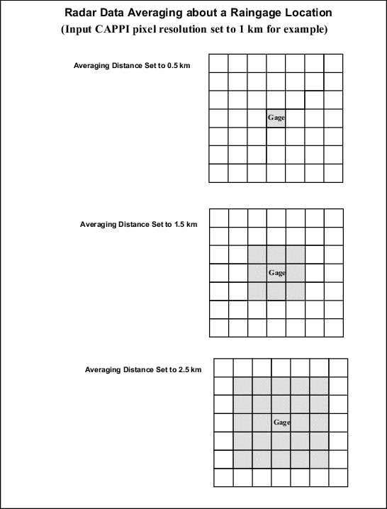
RADAR_AVERAGEThis is the distance in km around the raingage where the radar reflectivities shall be averaged. In the case where the input CAPPI resolution is 1 km (0.6 mi) (for example, maximum range of 240 km (149.1 mi) and 480 × 480 pixels), setting the Averaging Distance to 1.5 km (0.9 mi) would result in averaging over 3 × 3 pixels centered about the pixel containing the gage. The following figure shows some examples.
-
-
Define IRIS Setup configurations.