

Configuring MLHGT Products
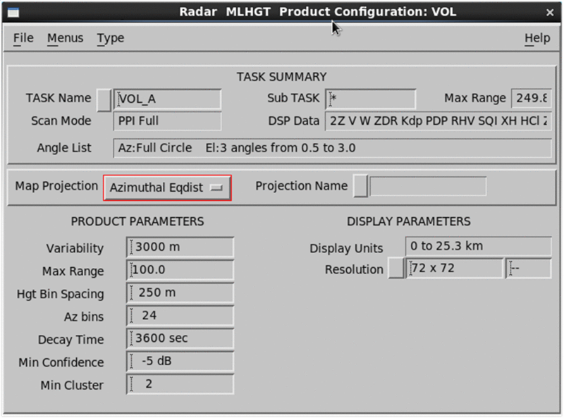
Use the IRIS MLHGT Product Configuration menu to configure the MLHGT product.
- Select .
-
Configure the MLHGT product:
- Variability
-
The MLHGT algorithm uses climatological melting level altitude as an initialization parameter in the Bayesian inference.
The Variability field sets the realistic limits of allowed MLHGT solutions centered at the climatological melting levels configured in Ingest/Setup utility.
For example, if the climatological melting level height is typically 3 km (1.9 mi) above sea level and the variability is set at 3000 m (9842 ft 6 in), the accepted range for the solution is from 1.5 ... 4.5 km (0.9 ... 2.8 mi).

You can still use the setup_changefunction to automatically update 0 °C heights from other sources, such as radiosonde or NWP, on a more timely basis. - Hgt Bin Spacing
-
An Earth co-ordinate grid system is created where a MLHGT value is derived for each grid point. This field sets the vertical bin spacing centered on each grid point.
Data in the vertical bins are used as input to the height determination. Allowable inputs are between 50 ... 2000 m (164 ft 1 in ... 6561 ft 8 in).
- Az bins
- The spatial resolution varies as a function of range due to the
broadening of the radials. This field defines how many column sectors exist in the
360° of view. For example, if you add a value of 24, there are 24 columns for each
range interval, each having a size of 15° (360/24 =15).
By specifying a small base scale of the grid, more
MeltClassifierestimates are needed as input to achieve a given confidence level.Specifying a large grid scale lowers the overall resolution.
You may wish to achieve something in between, which provides sufficient data availability at the desired confidence levels with higher resolutions.
- Decay Time
-
As confidence of the MLHGT estimates decreases, either by lack of radar observations or latency in time, the MLHGT Bayesian approach smoothly transitions the estimates from the radar observed height to the climatological melting level height at every grid point.
The Decay Time field sets the length of the time window for this smooth transition. The default value is 1 hour.
- Min Confidence
- At each grid point the MLHGT algorithm checks the confidence in the radar MLHGT estimate by comparing it with those in the neighboring grids. The confidence is accepted if it exceeds the minimum confidence level defined in this filed AND a minimum number of neighbors meet the confidence. Else the confidence in the estimate is set to a very low value.
- Min Cluster
- Defines the minimum number of neighbors needing to achieve the confidence.