

MLHGT Algorithm
IRIS dual polarization raw volume data is used as input for the MLHGT algorithm. This data may come from either single PPI, volume, RHI, or sector scans. The algorithm also functions independently from scan geometry matching data from the scan polar co-ordinate system to an Earth relative co-ordinate system. However as with any radar observation, a higher number of elevations in a volume scan provides the best results.
The following figure shows the MLHGT algorithm flow diagram. The top level illustrates the radar observation inputs, followed by prior information. The blocks represent consecutive functional steps. A key qualifier for each step is expressed in parenthesis.
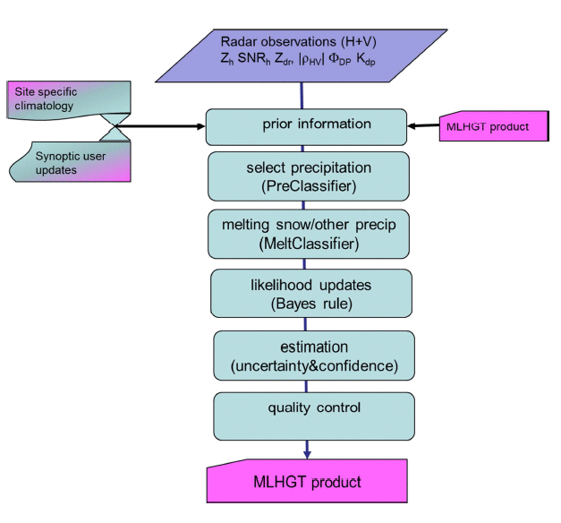
The first step in the processing is to ensure
only precipitation particles are being considered for the melting level height estimates. The
PreClassifier tags each range bin as being from precipitation or
non-precipitation targets. The non-precipitation flagged bins are removed from the considered
data.
The precipitating bins are then classified
into 'melting snow' or 'other precipitation' by a dedicated fuzzy algorithm known as
MeltClassifier. MeltClassifier is similar to the
MeteoClassifier used in HydroClass. However, the
MeltClassifier substitutes a Signal to Noise Ratio (SNR) Membership
function (MBF) in place of the melting level height MBF used by the
MeteoClassifier. The SNR MBF is configured for low SNR to be part of the
'melting snow' and high SNR in 'other precipitation'. Other particle types such as rain, dry
snow, hail, and graupel which are normally characterized or also grouped into the 'other
precipitation' class.
The statistical method known as Bayesian Rule is used to infer the likelihood of a region being either 'melting snow' or 'other precipitation', using a priori information and posterior conditioning. The a priori information is the first estimate of the 0 °C heights from an outside source. This could be automatically inserted from radiosonde or NWP data, or could come from the climatological values found in IRIS/Setup.
The likelihood of the
MLHGT can be updated by each subsequent radar observation over time
building up a confidence in the estimate. If there are a high number of 'melting snow' or
'other precipitation' bins in a region, and the ratio of one condition versus the other is
high, confidence increases quickly. Likewise, if there is a low number of classifications in
the region or if the ratio of 'melting snow' to 'other precipitation' is almost equal, the
confidence remains low. Once the minimum confidence is reached the melting level height form
MLHGT is assigned to that region, else the height remains to be the climatological value. The
Bayesian inference can be conceptually understood as constructing a display of vertical
cross-sections in which the most likely position of the ML can be visually recognized by
inspection of the MeltClassifier decisions.
The regions are presented as columns of data in an Earth co-ordinate system. The user is allowed to configure the vertical resolution and azimuthal size of each region. The columns size in range domain are scaled to match their size in azimuth. The columns range extent grows proportionally as the size in azimuth as distance from the radar increases. Thus the columns are effectively the same shape throughout the domain. This is advantageous because the statistics is improved at farther distances, due to an increasing number of data points, which compensates for the loss in resolution by beam broadening.