

SRI Algorithm
The SRI reflectivity profile and melting level estimation are not perfect, but they can improve the rainfall estimates compared to performing no correction. The typical corrections obtained are of the order -10 ... +5 dBZ (in mm/h scale up to factor of 4) depending on the melting level altitude, distance from radar, and the lowest elevation angle.
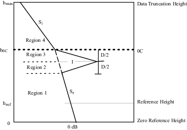
The profile includes the following:
-
Height
h=0corresponds to theZero Reference Height.This is typically set at either the nominal ground level or sea level.
-
The max height corresponds to the
Data Truncation Height. -
The reflectivity varies linearly in dBZ above and below the bright band.
Separate slopes are used above and below the bright band (
Srfor rain andSifor ice). - The bright band starts at the 0°C level
(
h=h0C), has depth (D) and intensity (I), defined as the intensity difference between the peak and the intensity the rain would have at the center of the bright band, that is, determined by the continuation of the rain slope into the bright band.
The surface rainfall intensity at each pixel is calculated by finding the lowest clutter-free bin, and bringing the measured reflectivity there down to reference level by making 2 corrections:
- The correction for the beam weighted averaging.
- The adjustment for the profile to obtain the reflectivity at the reference height.
The SRI product also supports using a terrain map to determine the height that that radar beam is corrected to. See Format of Terrain Map File.
Convective Check Algorithm
In convective precipitation there is usually no detectable bright band or perhaps a very weak one. This is thought to be caused by the types of particles near the melting level that are typical of convective precipitation. These are usually heavily rimed snowflakes, graupel, frozen drops (carried aloft), or hail. Since these particles tend to fall more rapidly than snow aggregates, they do not contribute to a bright band in the same way as large wet snow flakes falling at 1 m/s. That is, there is no convergence of large wet particles.
In cases where the precipitation is convective, it is not appropriate to perform a profile correction that includes a bright band and serious errors could result from doing this. In the SRI product this is handled by detecting convective regions and not applying any profile correction. That is, the measured value of the lowest clutter free bin is assigned to the reference height. This is done because in convective regions, the vertical reflectivity in the lower altitudes tends to be rather constant in height.
Each range bin is checked to determine if it is a convective range bin. The approach is to run an echo TOPS algorithm in the SRI product for a selectable threshold. Note, this is done in the SRI so there is no need to define a separate TOPS algorithm.
The product, in cylindrical coordinates, is made at the same resolution as that selected for the SRI product. It is then used as a mask for determining convective regions. That is, any bin in a ray for which the top height is more than a selectable height above the melting level is assumed to be convective.